Discover Magdalena Abakanowicz Pedestrian and Bicycle Footbridge
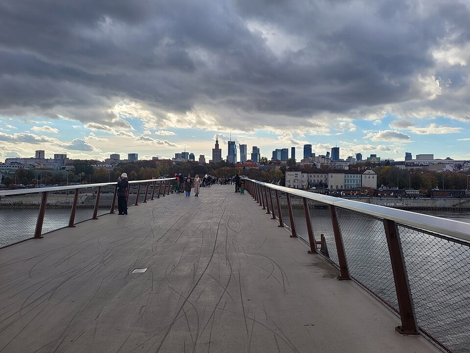
Cross the Vistula on Warsaw’s contemporary walking-and-cycling bridge, with broad river views and easy connections between central Warsaw and Praga. The public crossing opened in 2024 and was subsequently named in honour of Polish sculptor Magdalena Abakanowicz. The 452-metre bridge links the Vistula boulevards on the left bank with the Praga riverbank on the right. Its changing width and widened viewing areas make the crossing both a transport link and a place to pause.
Visit tips
The bridge is an open-air crossing: use suitable footwear during rain, frost or strong wind. Give cyclists space, keep to marked routes and follow posted safety instructions. Allow time for the riverside approaches as well as the bridge itself.
Why it stands out
- Observe the zigzag alignment of the pedestrian and cycle structure
- Look toward Warsaw’s riverfront and the changing skyline from the viewing areas
- Notice how the two banks offer contrasting urban and natural surroundings
About the place · Management and care
About Magdalena Abakanowicz Pedestrian and Bicycle Footbridge
Managed or overseen by: City of Warsaw — public pedestrian and cycling infrastructure
This bridge is a Warsaw public crossing connecting the Vistula boulevards and Praga. Its use, upkeep and any temporary restrictions are handled through the city’s relevant infrastructure services; the adjoining riverside areas have their own maintenance arrangements.
Institution or city information ↗History and local significance
Opened in 2024, the pedestrian-and-cycle crossing links the central Vistula boulevards with Praga on the eastern bank. It was named after the influential Polish sculptor Magdalena Abakanowicz. The roughly 452-metre bridge is part of Warsaw’s effort to reconnect everyday life with its riverfront.
At a glance
- Destination
- Magdalena Abakanowicz Pedestrian and Bicycle Footbridge
- Area
- warsawPoland
- Guide type
- Nearby attractions
- Navigation
- Google Maps for this location ↗
- Type of attraction
- Pedestrian and bicycle bridge
- Location
- Vistula River, connecting central Warsaw and Praga
- Suggested duration
- 30–60 minutes including riverside approaches
- Management
- City of Warsaw — public pedestrian and cycling infrastructure
Opening hours and access
Outdoor public-space viewing is generally possible throughout the day; temporary closures can occur during events, maintenance or conservation work.
Tickets and admission
No separate ticket is normally required to view the outdoor public area. Nearby museums, towers and exhibitions may charge admission.
Getting here
Reach the central Vistula boulevards near the Copernicus Science Centre, then follow the signed bridge approach.
For the final approach, open this attraction’s own Google Maps location ↗.
History, design and setting
The crossing is intentionally not a straight, uniform strip: turns and widened areas shape the experience of walking over the river. Railings, a textured deck and viewpoints allow people to notice both the water and the city skyline.
Highlights and what to notice
- Watch how the bridge changes width at viewing areas.
- Compare central Warsaw’s dense skyline with the Praga riverbank.
- Observe cyclists and pedestrians sharing the crossing responsibly.
Planning your visit
The bridge is an open-air crossing: use suitable footwear during rain, frost or strong wind. Give cyclists space, keep to marked routes and follow posted safety instructions. Allow time for the riverside approaches as well as the bridge itself.
Check any venue's current opening information, ticket requirements and temporary access notices before setting off. Outdoor public spaces and staffed attractions may follow different rules.
Visitor essentials
Share the crossing with cyclists; exposed river conditions can be windy or slippery.
Plan your walking sequence around the surrounding landmarks rather than visiting only one photo spot. Nearby cafés and indoor venues can make useful weather breaks, provided their own hours and access arrangements suit your day.
Walking route: step by step
From the Vistula boulevards near the Copernicus Science Centre, walk toward the bridge, cross to Praga and continue along the east-bank paths. The Royal Castle and Sigismund’s Column can form an earlier Old Town stop.
- 1Approach from the Vistula boulevards on the city-centre bank.
- 2Pause at an appropriate wider viewing point.
- 3Cross toward Praga without blocking cycle movement.
- 4Continue along the opposite riverbank or return by the same bridge.
Photography viewpoints
Photograph the angled deck from either riverbank, then frame the city skyline through the bridge railings. Early and late daylight can be useful for reducing glare on the water.
Keep paths and entrances clear while framing your shot, and follow posted restrictions for museums and places of worship.
Where to stay nearby
Stay on either bank according to your wider itinerary; central Warsaw offers easier intercity connections.
Check each property’s actual address, accessibility and arrival arrangements before booking, particularly in historic streets with limited vehicle access.
Visitor impressions
Visitors often come for the historic surroundings and the chance to explore on foot. Assess crowd levels, weather and current access conditions for your own visit rather than relying on a fixed rating.
Google Maps for this location ↗Location and directions
Vistula River, connecting central Warsaw and Praga
Open the exact destination in Google Maps ↗Before you go: common questions
Is the bridge for cars?
No. It is intended for pedestrians and cyclists.
How long is it?
Warsaw’s city information gives a length of approximately 452 metres.
Who was Magdalena Abakanowicz?
A major Polish sculptor whose name was given to the crossing after it opened.
Where should I navigate?
Use the destination-specific map link for Kładka pieszo-rowerowa im. Magdaleny Abakanowicz Warsaw Poland, rather than the map pin for Sigismund’s Column or a different Warsaw attraction.
What else fits into the same visit?
From the Vistula boulevards near the Copernicus Science Centre, walk toward the bridge, cross to Praga and continue along the east-bank paths. The Royal Castle and Sigismund’s Column can form an earlier Old Town stop.
Explore more nearby attractions
Continue your Warsaw visit with a destination-specific guide. Each link covers its own history, visitor information, walking approach and Google Maps location.
- Warsaw Old Town Defensive Walls →
- St. Anne’s Church Viewing Terrace →
- Our Lady of Graces Jesuit Church →
- St. Martin’s Church on Piwna Street →
- Kanonia Wishing Bell →
- Gnojna Góra Viewpoint →
- Castle Square Warsaw →
- Royal Castle in Warsaw →
- St. Anne’s Church Warsaw →
- Warsaw Old Town Market Square →
- Warsaw Mermaid Statue →
- Warsaw Barbican →
- St. John’s Archcathedral →
- Kanonia Square →
- Museum of Warsaw →
- Krasiński Palace Warsaw →
- Presidential Palace Warsaw →
- Adam Mickiewicz Monument Warsaw →
- Multimedia Fountain on the Vistula Boulevards →
Further reading: Official institution information ↗